
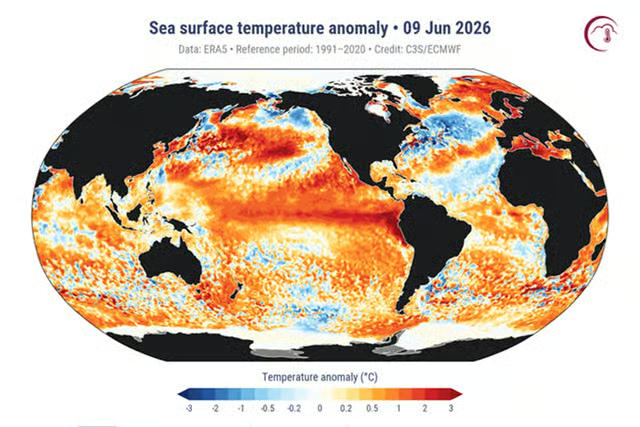
Meteorologists are warning that a rapidly strengthening El Niño in the Pacific Ocean could become one of the most powerful events ever recorded, potentially rivaling or even surpassing the legendary 1997-1998 “Super El Niño.”
Scientists say the developing climate pattern could dramatically increase the risk of record-breaking heatwaves, devastating floods, prolonged droughts, destructive wildfires, and severe storms across large parts of the world over the coming months.
The U.S. National Oceanic and Atmospheric Administration (NOAA) has officially confirmed the arrival of El Niño, with forecasters warning there is a significant probability that this event could rank among the strongest observed since modern records began in 1950.
Scientists Warn of a Potential “Godzilla” El Niño
Climate experts have already begun referring to the developing event as a “Super El Niño” or even “Godzilla El Niño” because of its extraordinary early development and the potential for exceptional global impacts.
According to NOAA, there is a 63% probability that the phenomenon will strengthen into one of the largest El Niño events ever documented during late autumn and early winter.
Researchers note that unusually warm ocean waters have already developed across the equatorial Pacific, creating conditions capable of influencing weather systems across nearly every continent.
An Already Warming Planet Could Make the Impacts Worse
Scientists stress that this El Niño is developing in a world that is already experiencing record global temperatures driven by climate change.
The combination of natural ocean warming and long-term human-induced global warming could amplify extreme weather events far beyond what has historically been observed during previous El Niño episodes.
United Nations Secretary-General António Guterres described the development as an urgent warning, saying El Niño could “pour fuel on the fire of a warming world.”
What Is El Niño?
El Niño is a naturally occurring climate pattern caused by unusually warm sea surface temperatures across the central and eastern equatorial Pacific Ocean.
Although it begins in the Pacific, its influence extends worldwide by altering atmospheric circulation patterns, affecting rainfall, temperatures, hurricanes, droughts, and severe weather events across multiple continents.
Typically, El Niño develops during the summer, peaks in late autumn or winter, and gradually weakens during the following spring.
Every Region Experiences Different Impacts
One of the defining characteristics of El Niño is that its effects vary dramatically from one part of the world to another.
Some regions experience devastating floods while others face prolonged droughts and record-breaking heat.
Meteorologists emphasize that understanding these regional differences is critical for emergency preparedness and disaster planning.
Heatwaves, Floods, Droughts and Wildfires Could Intensify
Scientists expect this El Niño to significantly increase the likelihood of extreme weather across many parts of the globe.
Western South America may experience exceptionally heavy rainfall and severe flooding, while Australia faces an elevated threat of drought, intense heatwaves, and destructive wildfires.
India could see stronger and more prolonged heatwaves, while parts of northeastern Africa may swing rapidly between severe drought and torrential rainfall.
Across many regions, elevated temperatures could increase stress on agriculture, water supplies, ecosystems, and public health systems.
Impacts on Hurricanes and Tropical Storms
El Niño also has a major influence on tropical cyclone activity.
Historically, El Niño tends to suppress hurricane development across the Atlantic Basin by increasing upper-level wind shear, although it does not eliminate the risk entirely.
At the same time, tropical cyclone activity often becomes more active across parts of the Pacific Ocean, increasing risks for islands and coastal regions exposed to powerful storms.
Could This Rival the Historic 1997-1998 Event?
The 1997-1998 El Niño remains one of the strongest ever observed and caused billions of dollars in damage worldwide.
That event produced devastating floods in some regions while triggering severe droughts, agricultural losses, deadly heatwaves, and widespread economic disruption elsewhere.
Current forecasts suggest the developing El Niño could rival—or potentially exceed—that historic episode in overall strength.
Several climate models also indicate that this event could last longer than average, prolonging its influence well into next year.
Early Signs Have Been Exceptionally Strong
Climate researchers note that one of the most remarkable aspects of the current event is how consistently forecasting models agree on its likely intensity.
Warm water moving toward the ocean surface and rapidly evolving atmospheric conditions have provided unusually strong early signals, giving forecasters greater confidence than is typical at this stage of development.
Scientists continue to monitor ocean temperatures and atmospheric conditions closely as the event evolves.
Governments Urged to Prepare
Climate experts emphasize that the focus should not be on fear but on preparedness.
Governments, emergency agencies, and communities are being encouraged to strengthen disaster planning, improve early warning systems, and prepare for possible increases in flooding, droughts, wildfires, and severe weather events over the coming months.
While the exact impacts will differ from region to region, experts agree that the developing El Niño has the potential to become one of the defining climate events of the decade.


