The global weather system may be entering a major new phase as the tropical Pacific begins shifting away from La Niña and toward El Niño conditions in 2026. According to the latest official ENSO Diagnostic Discussion from NOAA’s Climate Prediction Center, La Niña is expected to transition to ENSO-neutral in the near term, while El Niño is likely to emerge during June–August 2026 with a 62% chance and continue through at least the end of the year.
What is drawing even more attention now is not just the probability of El Niño forming, but how quickly the ocean-atmosphere system appears to be changing. NOAA says subsurface temperatures in the equatorial Pacific have become above average, with the greatest positive anomalies expanding across the central and eastern Pacific. The International Research Institute for Climate and Society also shows El Niño probabilities rising sharply from late spring into summer 2026, signaling that the background state of the Pacific is changing fast.
From La Niña to El Niño: what the latest official forecasts show
The latest NOAA outlook says ENSO-neutral is favored through May–July 2026, but El Niño becomes the most likely outcome in June–August. NOAA also stresses that the potential strength of the event remains uncertain. At this stage, there is roughly a one-in-three chance that the event could become “strong” during October–December 2026, based on Niño 3.4 values of at least +1.5°C.
The IRI forecast broadly supports that direction of travel. Its March 2026 update shows El Niño probabilities increasing strongly by summer and remaining favored into late 2026. At the same time, IRI cautions that forecasts made during the spring are affected by the well-known “spring predictability barrier,” meaning confidence in exact intensity remains lower than many headlines suggest.
Why ENSO matters for weather around the world
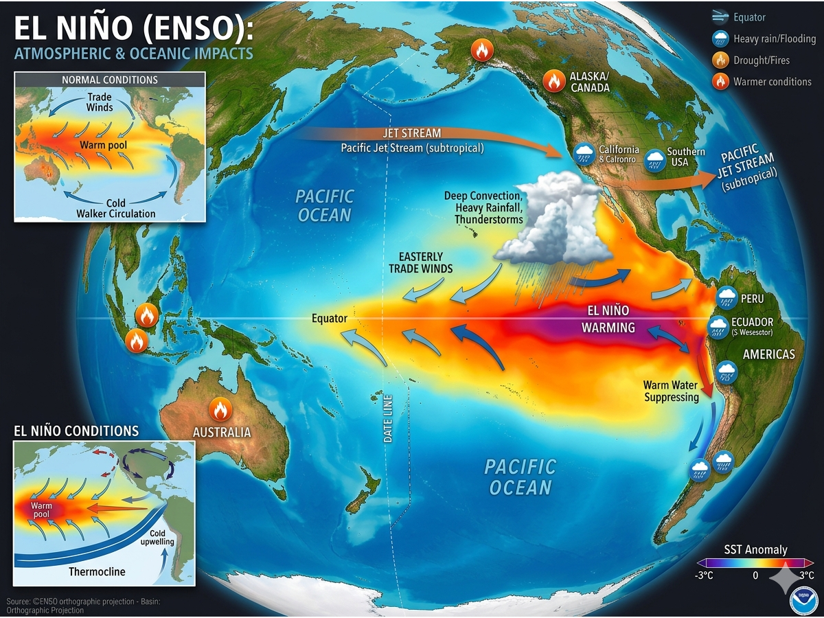
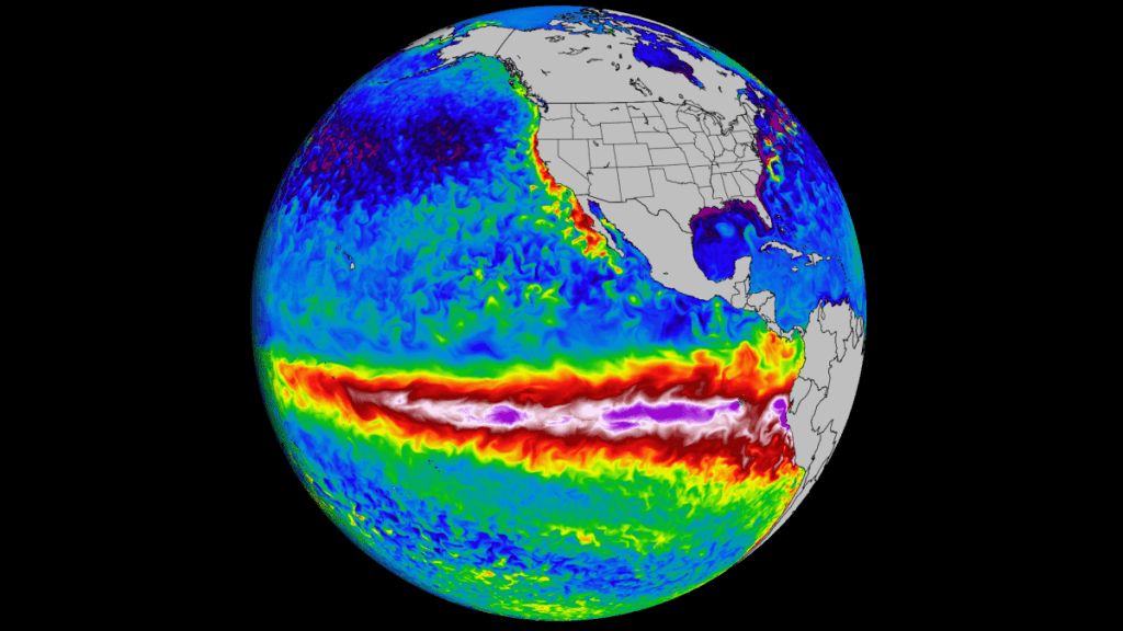
ENSO, short for El Niño–Southern Oscillation, is one of the most important large-scale climate drivers on Earth. When El Niño develops, sea-surface temperatures in the central and eastern tropical Pacific become warmer than normal, and that change can influence jet streams, pressure patterns, rainfall distribution, and seasonal temperature trends far beyond the Pacific basin. NOAA’s latest discussion notes that atmospheric and oceanic conditions are already moving away from La Niña, while IRI highlights the rapid increase in the odds of El Niño later this year.
That does not mean every country will experience the same outcome. It does mean that the global “background pattern” for weather can shift. In practical terms, El Niño can raise the odds of altered storm tracks, unusual rainfall patterns, drought risk in some regions, flood risk in others, and meaningful changes in winter circulation across parts of the Northern Hemisphere.
Is this heading toward a “Super El Niño”?
That is the big question, but it is also where caution is needed. Officially, NOAA has not declared that a Super El Niño is developing. What NOAA says right now is that El Niño is likely to emerge, and if it does, there is about a one-in-three chance it reaches strong intensity by late 2026. That is a notable signal, but it is not the same as a confirmed record-breaking or “super” event.
Still, there are clear reasons why forecasters are watching this closely. The warming below the surface in the equatorial Pacific has strengthened, and the probability guidance from both NOAA and IRI points toward a meaningful warm-phase event later this year. So while it is too early to state with confidence that this will be one of the strongest El Niño events in decades, it is fair to say that the signal has become strong enough to put the global weather community on alert.
The first possible impacts in Summer 2026
If El Niño begins coupling more effectively with the atmosphere by summer, the earliest effects are more likely to appear in broad regional patterns rather than city-level forecasts. IRI notes that El Niño events typically peak between October and February, which means summer 2026 may represent the early atmospheric response phase rather than the full mature impact period.
For North America, El Niño often changes the positioning of the jet stream and influences temperature and precipitation patterns on seasonal scales. In other parts of the world, including Australia, El Niño can shift rainfall distributions in ways that increase drought risk. The exact footprint varies from event to event, but the overall mechanism is the same: a warmer tropical Pacific can reshape atmospheric circulation well beyond the tropics.
What it could mean for the Atlantic hurricane season
One of the best-known impacts of El Niño is its tendency to suppress Atlantic hurricane activity. Official U.S. National Weather Service guidance explains that hurricane chances for the continental United States and the Caribbean increase during La Niña and decrease during El Niño, largely because El Niño tends to favor conditions less supportive of tropical cyclone development.
That matters for 2026 because if El Niño becomes established through the second half of the year, it could act as a limiting factor on Atlantic tropical activity. That does not mean the basin shuts down completely, and it certainly does not eliminate the risk from individual storms. But on a seasonal basis, El Niño is generally considered a negative signal for a very active Atlantic season.
Winter 2026/2027 could be the key period
If El Niño strengthens into autumn, Winter 2026/2027 will likely be the season when its largest teleconnections become more visible. IRI notes that El Niño events usually peak from October through February, which is why winter is often the most revealing period for larger-scale impacts on circulation, storm tracks, and precipitation patterns.
Europe is always more complex. Unlike parts of North America, Europe is not directly and consistently controlled by ENSO. Atlantic pressure patterns and other regional climate drivers can amplify, distort, or even partly mask the El Niño signal. So it would be too strong to claim that Europe is “certain” to experience one specific winter pattern because of El Niño alone. The more accurate framing is that a strong El Niño can alter the broader hemispheric background and tilt the odds toward some outcomes, without dictating every regional detail months in advance.