A new El Niño could reshape the 2026 hurricane season
A potentially powerful El Niño climate pattern is expected to develop during the summer of 2026, raising questions about its impact on the upcoming Atlantic hurricane season.
Forecasters note that El Niño could suppress storm activity across the Atlantic, although there is still significant uncertainty regarding how strong the event will become.
The current La Niña pattern is fading, and the National Oceanic and Atmospheric Administration (NOAA) estimates a 62% chance that El Niño will form between June and August.
What is El Niño and how it affects the weather
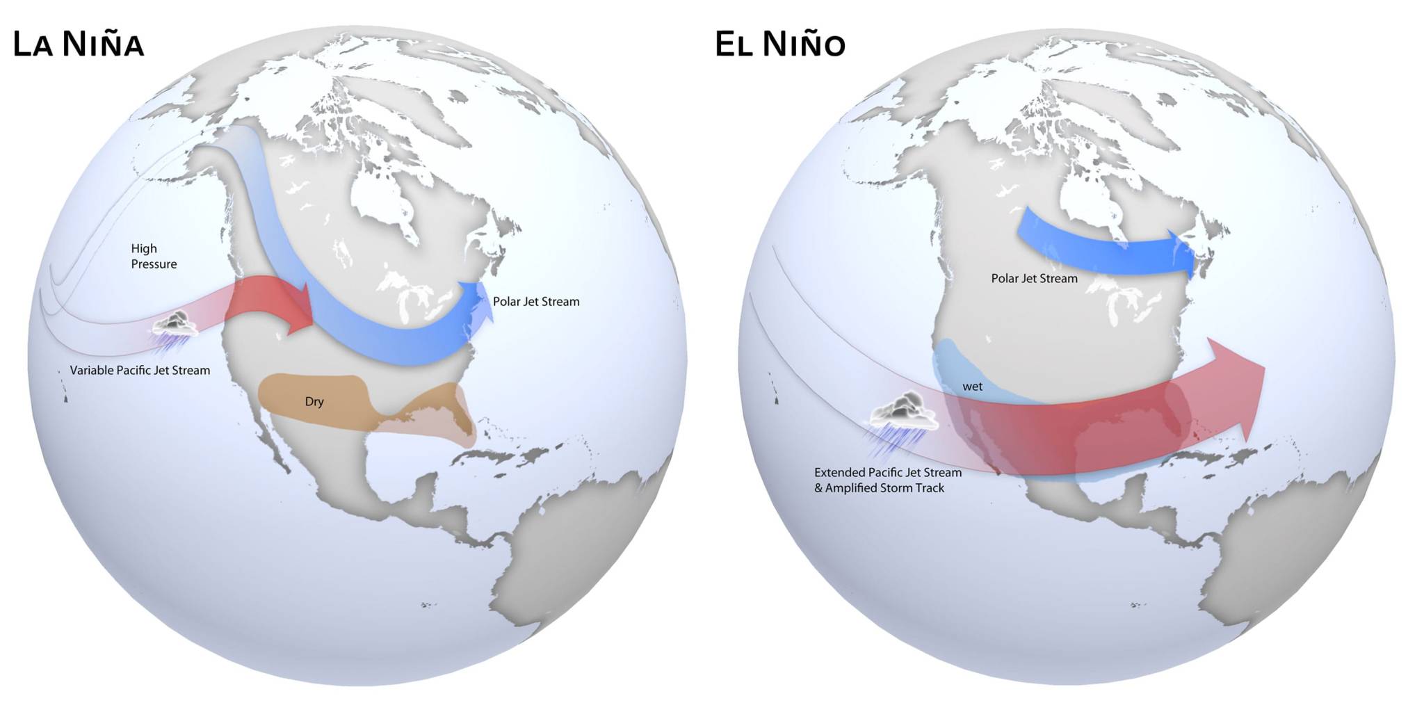
El Niño occurs when sea-surface temperatures in the equatorial Pacific Ocean rise above average levels. This warming weakens the trade winds and disrupts normal atmospheric circulation, leading to widespread weather changes across North America and other parts of the world.
These changes can influence rainfall patterns, temperatures, and storm development over vast regions.
Could this become a “Super El Niño”?
Forecasters say there is roughly a one-in-three chance that the event could intensify into a so-called “Super El Niño” by late 2026.
In such a scenario, sea-surface temperatures could rise about 1.5°C above average, making it one of the strongest warming events in recent years and potentially comparable to the powerful 2023–2024 episode.
Impact on the Atlantic hurricane season
One of the most important questions is how El Niño will affect hurricane activity in the Atlantic.
Typically, El Niño increases wind shear over the Atlantic Basin during summer and autumn. This wind shear can disrupt developing tropical systems, preventing them from strengthening into hurricanes.
However, experts emphasize that El Niño does not guarantee a quiet hurricane season.
A recent example is the 2023–2024 El Niño, one of the strongest on record, which still saw an active hurricane season with 20 named storms, significantly above the historical average. That season included Hurricane Idalia, which made landfall in Florida as a Category 3 storm.
In that case, unusually warm Atlantic waters helped offset El Niño’s suppressing effects.
Broader impacts on weather patterns
Beyond hurricanes, a strong El Niño could influence weather patterns across the United States and globally.
Southern regions, including Florida, may experience wetter and cooler conditions during winter, while northern areas could remain relatively warm and dry.
During summer, however, El Niño is not expected to significantly alter daily weather in places like South Florida, where local thunderstorms are primarily driven by localized atmospheric conditions.
Global temperatures and climate outlook
El Niño also plays a major role in global temperature trends.
According to NOAA, 2025 was the third-warmest year on record, and there is a greater than 90% chance that 2026 will rank among the five warmest years globally.
The probability of 2026 becoming the single warmest year on record remains low at around 1%, but that could increase in 2027 if a strong and long-lasting El Niño develops.
What comes next
NOAA is expected to release its official outlook for the 2026 Atlantic hurricane season in May, ahead of the season’s official start on June 1.
Until then, scientists will continue to monitor ocean temperatures and atmospheric patterns to determine how strong this developing El Niño could become.